Weather news
Melbourne's 11.51 inches and Norfolk's 6.31 lead a week of November records
By Ryan Hall, Y'all Weather Desk · Published · Updated
Written by our automated news desk from National Weather Service data.
What's new: Added today's South Texas flood advisories, tightened the Texas timing, and dropped the old records map.
Key points
- Where: Records fell in Florida, Virginia, the Great Lakes, the northern Plains and the Pacific Northwest between Nov. 1 and Nov. 7.
- Rain: Melbourne got 11.51 inches on Nov. 2. Norfolk got 6.31 inches on Nov. 6.
- Warmth: Buffalo hit 79 on Nov. 4, and Bismarck had its warmest November low on record.
- Today: South Texas, mostly south of I-10, can see 3 to 6 inches of rain, locally up to 8, with the best chance for flash flooding from late afternoon through early Monday, Central time.
Updated 11:15 AM ET Sunday.
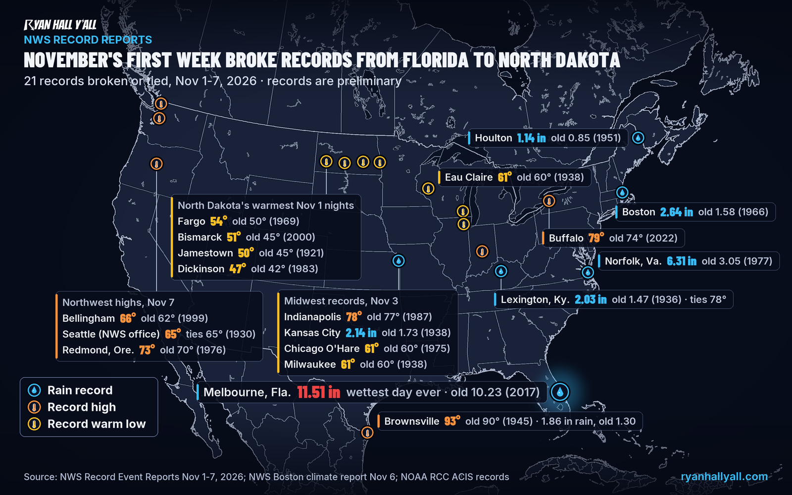
Melbourne, Florida, picked up 11.51 inches of rain on Monday, Nov. 2, its wettest day on record, and Norfolk, Virginia, had its wettest November day ever on Friday with 6.31 inches. Record warm afternoons and nights also showed up from Buffalo to North Dakota. The next heavy rain is in South Texas today, where flood advisories are already up and a Level 2 of 4 (Slight Risk) for flash flooding runs into early Monday.
Melbourne had its wettest day ever, and it wasn't a hurricane
Melbourne International Airport measured 11.51 inches on Nov. 2. The old one-day record was 10.23 inches, set on Sep. 10, 2017, when Hurricane Irma came through. It also left the old wettest November day there, 5.45 inches in 1977, far behind.
Norfolk and the East Coast soaked up record rain
Norfolk measured 6.31 inches on Nov. 6, more than double the old record for the date, 3.05 inches in 1977. That is the wettest November day on record there, topping 5.02 inches in 1893, and the 8th wettest day of any month. Boston picked up 2.64 inches the same day, a record for the date.
Rain records also fell elsewhere:
- Kansas City: 2.14 inches on Nov. 3.
- Lexington, Kentucky: 2.03 inches on Nov. 4.
- Brownsville, Texas: 1.86 inches on Nov. 6.
- Houlton, Maine: 1.14 inches on Saturday.
Warm afternoons and record-warm nights
Buffalo reached 79 on Nov. 4, beating the old record for the date by 5 degrees. That ties the second-warmest November reading there. The warmest is 80, back in 1961. Indianapolis hit 78 on Nov. 3, and Lexington tied its record high of 78 the same day. Brownsville reached 93 on Nov. 3.
The nights were just as unusual:
- Bismarck, North Dakota, only fell to 51 on Nov. 1, its warmest November low on record. Fargo stayed at 54, a record for the date.
- Eau Claire, Wisconsin, bottomed out at 61 on Nov. 3, the warmest November low there.
- Chicago O'Hare and Milwaukee both held at 61 that night, records for the date.
The warmth reached the Pacific Northwest on Saturday. Bellingham, Washington, hit 66, and Redmond, Oregon, reached 73. Seattle tied its record of 65.
South Texas has the next round of heavy rain
A slow-moving disturbance over northern Mexico is feeding waves of storms across South Texas. Flood advisories are up this morning for Kleberg County, around Kingsville, and southwestern Cameron County, near Brownsville. More flash flood warnings may be needed as storms keep passing over the same ground.
Expect 2 to 4 inches during the afternoon and early evening, with storms re-firing overnight. Totals of 3 to 6 inches, locally up to 8, are likely south of I-10. The heaviest rain should fall from Laredo's Webb County over toward Corpus Christi. The rain itself is well set up. Exactly where the 8-inch spots land is not.
There is also a Level 1 of 5 (Marginal Risk) for severe storms near Corpus Christi, Alice, Falfurrias and Kingsville. A storm there could bring isolated damaging wind or a brief tornado. Monday drops to Level 1 of 4 for flash flooding, with 0.5 to 1 inch more, though a few spots could pick up 2 to 4 inches on already soaked ground.
What to do
- If you're south of I-10 in Texas, plan to be off the roads when the heaviest rain arrives this afternoon and evening.
- Don't drive into water over the road, especially after dark.
- Turn on phone alerts before tonight so an overnight warning wakes you. You can sign up for Y'all Alerts free.
- Check the flash flood outlook and the live warnings page before you head out Monday morning.
Bottom line
A week of record rain and warmth is in the books, from Melbourne's all-time soaking to North Dakota's mild nights. South Texas gets the next dose today and tonight.
| Place and date | New value | Old record |
|---|---|---|
| Melbourne, FL, Nov 2 (rain) | 11.51 in | 10.23 in, Sep 10, 2017 |
| Norfolk, VA, Nov 6 (rain) | 6.31 in | 5.02 in, Nov 8, 1893 (November record) |
| Boston, MA, Nov 6 (rain) | 2.64 in | 1.58 in, 1966 |
| Buffalo, NY, Nov 4 (high) | 79 F | 74, 2022 |
| Bismarck, ND, Nov 1 (low) | 51 F | 45, 2000 |
| Eau Claire, WI, Nov 3 (low) | 61 F | 60 F, Nov 2, 1938 (November record) |
Explained: Flood Advisory, Watch, Warning and Flash Flood Warning explained
More on Weather records, November 2026
Places in this story: Melbourne, FL; Norfolk, VA; Boston, MA; Buffalo, NY; Bismarck, ND; Fargo, ND; Eau Claire, WI; Kansas City International, MO; Lexington, KY; Indianapolis, IN; Chicago O'Hare, IL; Milwaukee, WI
Sources
- NWS Record Event Reports (RER) Nov 2-7, 2026 via api.weather.gov, National Weather Service
- NWS Boston CLI Nov 6, 2026, National Weather Service
- NOAA Regional Climate Centers ACIS threaded records (all-time ranks), NOAA Regional Climate Centers (ACIS)
- NWS Caribou Record Event Report (Houlton rainfall), National Weather Service, issued
- NWS Seattle Record Event Report (Seattle WFO high tied), National Weather Service, issued
- NWS Melbourne Record Event Report, National Weather Service, issued
- NWS Wakefield Record Event Report, National Weather Service, issued
- NWS Boston climate report (CLI) for Nov 6, National Weather Service, issued
https://ryanhallyall.com/news/melbournes-record-1151-inches-of-rain-led-a-week-of-november-records