Flooding
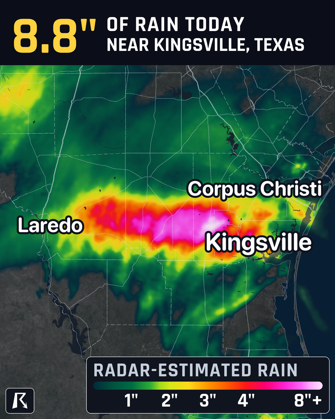
Nearly 9 inches of rain near Kingsville, Texas; Flood Watch lasts into Monday
By Ryan Hall, Y'all Weather Desk · Published · Updated
Written by our automated news desk from National Weather Service data.
What's new: Flash Flood Warnings in parts of South Texas until as late as 1:30 PM Central, Kingsville airport gauge at 7.03 inches, flooded low-water crossings reported north of Premont
Key points
- Where: The heaviest rain is around Kingsville, southeast Jim Wells County and Kleberg County. Earlier warnings also covered Duval County, central Nueces County (which includes Corpus Christi) and Cameron County near Brownsville.
- When: Warnings for Nueces, Duval, Jim Wells, Kleberg and Cameron counties end between 12:45 and 1:30 PM Central. Another round of storms could build tonight, and the Flood Watch lasts through Monday morning.
- What: The top radar estimate is 8.8 inches, about 14 miles west of Kingsville. The Kingsville airport gauge recorded 7.03 inches since midnight.
- What it means: Roads and low water crossings are flooded in places. The ground is soaked, so new rain runs off fast.
Updated 1:45 PM ET Sunday.
Radar estimates show nearly 9 inches of rain since midnight just west of Kingsville, and a Flash Flood Warning for western Kleberg County runs until 1:30 PM Central. More heavy rain is possible this evening and overnight, and a Flood Watch runs through Monday morning. Water over roads is the main danger.
How much rain has fallen
The 8.8 inch number is a radar-based estimate for midnight to 11 AM Central, centered in southeast Jim Wells County. Gauges back it up. The Kleberg County Airport in Kingsville had recorded 7.03 inches, and it was still raining there. Kingsville NAS has 3.57 inches as of late morning. The totals fall off quickly away from the core. Corpus Christi and Alice each had about 2.3 inches, Hebbronville 1.85 and Laredo 1.17.
One warning for the area where Duval, Jim Wells and Kleberg counties meet said 4 to 7 inches had already fallen. A spotter 8 miles east of Realitos in Duval County reported 4.75 inches in three hours this morning.
Warnings and flooded roads
A Flash Flood Warning for western Kleberg County runs until 1:30 PM Central.
Low water crossings and water over roads were reported north of Premont, southwest of Kingsville, by mid-morning. A vehicle also got stuck in a flooded crossing in Del Rio, which is a separate area far to the northwest.
Check the live warnings page for current times, and the live storm reports for what people are seeing on the ground.
Tonight and Monday
Flash flooding is at Level 2 of 4 (Slight Risk) across South Texas today. Rain has mostly let up west of the main band, but the setup is not finished. Computer models show storms firing again this evening and overnight over ground that has already taken more than 2 inches. Some spots from east of Laredo to near Kingsville have taken over 5 inches. Our flash flood outlook tracks that risk.
How sure are we? Another round of rain is possible, but exactly where it sets up is not locked in. The Flood Watch is in place through Monday morning, with 2 to 5 inches common and isolated spots of 7 to 9 inches possible.
Monday drops to Level 1 of 4 (Marginal Risk). Rain should linger south and southeast of I-10, mostly an extra half inch to 1 inch. A few models push local totals to 2 to 4 inches in a narrow strip inland from the coast. The threat should fade after about noon Central Monday. Tuesday has no flash flood risk outlined.
What to do
- Do not drive through water over a road. Turn around and use another route.
- Plan the evening and overnight drive. If you travel around Kingsville, Alice, Premont, Corpus Christi or Brownsville after dark, check your route first. Flooded crossings are hard to see at night.
- Move cars off low ground if you park near a creek, ditch or low spot.
- Keep a way to get warnings overnight. Turn on phone alerts, or sign up for free Y'all Alerts.
- If a warning says to move to higher ground, go.
Bottom line
The worst rain so far has fallen near Kingsville, and the western Kleberg County warning runs until 1:30 PM Central. The flood threat is not over, with more storms possible tonight and lingering rain Monday, so keep out of flooded roads through Monday morning.
Explained: Flood Advisory, Watch, Warning and Flash Flood Warning explained
More on South Texas flooding, November 2026
Places in this story: Corpus Christi, TX; Laredo, TX
Sources
- Iowa Environmental Mesonet observations, Iowa Environmental Mesonet (Iowa State University)
- NWS Local Storm Reports, National Weather Service