Forecasts
Rain totals near 3 inches possible from central New Jersey to southern Maine today
By Ryan Hall, Y'all Weather Desk · Published
Written by our automated news desk from National Weather Service data.
What's new: The heaviest rain axis for the coastal low is now better focused from central New Jersey to southern Maine, with locally near 3 inches, and the low is no longer expected to become tropical or subtropical.

Key points
- New Jersey to southern Maine, Sunday into early Monday: Rain spreads north through the day, with the heaviest bands Sunday evening into the overnight hours. Expect ponding on roads and poor-drainage flooding, especially in southern New England.
- Massachusetts and Rhode Island, tonight: Level 2 of 4 flash flood risk. Don't drive into water over the road after dark.
- Lower Texas coast and the Rio Grande Valley, today: Level 2 of 4 flood risk, with 2 to 4 inches in spots. Strong storms are possible this afternoon and early evening around Corpus Christi, Brownsville and Alice (Level 1 of 5).
- Olympic Peninsula, Washington, Monday: Heavy mountain rain, up to about 3 inches in the terrain, could push the Skokomish River up.
- Upper Peninsula of Michigan, Monday: Colder air arrives and lake-effect snow starts.
Heavy rain from New Jersey to Maine Sunday; flash flood risk in South Texas
A fast-moving coastal low dumps 1 to 2 inches of rain from central New Jersey to southern Maine today, Sunday, Nov. 22, with local amounts near 3 inches. Massachusetts and Rhode Island sit under a Level 2 of 4 (Slight) flash flood risk, and the heaviest rain arrives Sunday evening into early Monday. South Texas also has a Level 2 of 4 flash flood risk today along the lower coast and in the Rio Grande Valley, with 2 to 4 inches in spots.
Heavy, fast rain from New Jersey to Maine
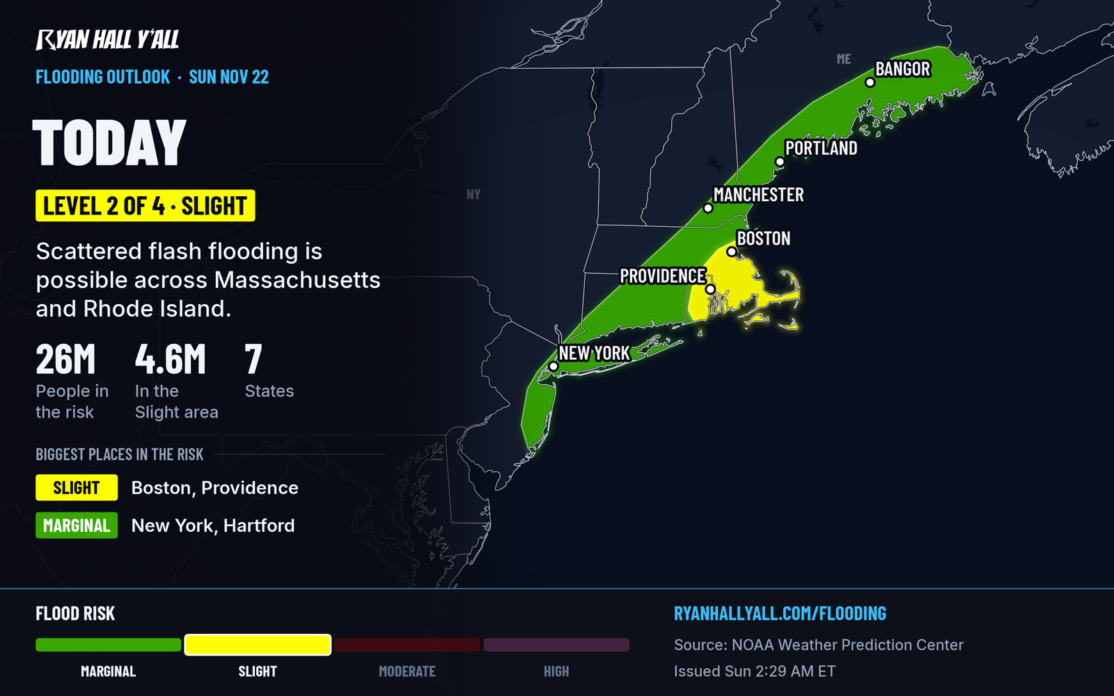
Rain moves across the Southeast and Mid-Atlantic today, then reaches the Northeast Sunday evening. The low then lifts into southeastern Canada by Monday evening. The best-fit track puts the heaviest rain from central New Jersey through southern New England to southern Maine. Most places get 1 to 2 inches, and a few spots near 3.
The rain falls in a hurry because the storm is moving fast. That means short bursts of very heavy rain, and that is what floods streets and underpasses. Plan around it in Boston, Providence, Hartford, Long Island and along the Connecticut coast. Give yourself extra time if you're driving home Sunday evening, and skip low spots and underpasses.
Rain tapers Monday from New Jersey to coastal Maine. Runoff can keep small streams and poor-drainage areas flooded into Monday morning. Gusty winds also bring rough surf, dangerous rip currents and some beach erosion along the coast. The surf and rip currents reach down the Southeast coast too, so stay out of the water at the beach.
Fog and heavy rain could cause delays at Boston and LaGuardia airports. Check the airport delay outlook before you leave for the airport.
The system offshore of the Southeast was watched as a possible tropical or subtropical storm. That is no longer expected, and nothing in the Atlantic has even a 1% chance of developing in the next week. It still brings the rain, wind and surf described here.
South Texas flood risk and a few strong storms today
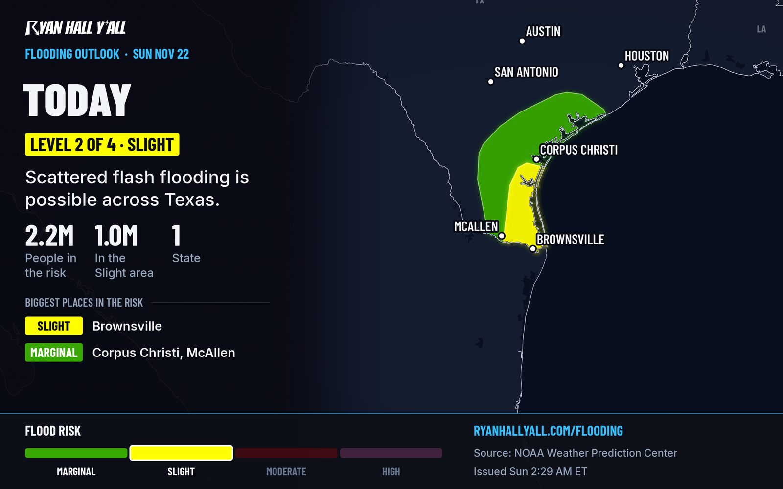
Deep South Texas has a Level 2 of 4 flash flood risk through tonight. Think of the lower Texas coast and the eastern Rio Grande Valley, including Brownsville, Corpus Christi and the area around them. Some spots could see 2 to 4 inches. Storms will also be strong this afternoon and early evening, with a Level 1 of 5 (Marginal) severe risk. Quarter-size hail is the main threat, with large-hail odds at 5%. If you're driving, don't enter flooded roads. Water over a road can hide a washed-out surface. Watch the sky if you're near Corpus Christi or Alice, and be ready to adjust if roads flood. Our severe outlook updates through the day. The front pushes offshore tonight and the storms weaken.
Heavy rain and mountain snow in the Pacific Northwest
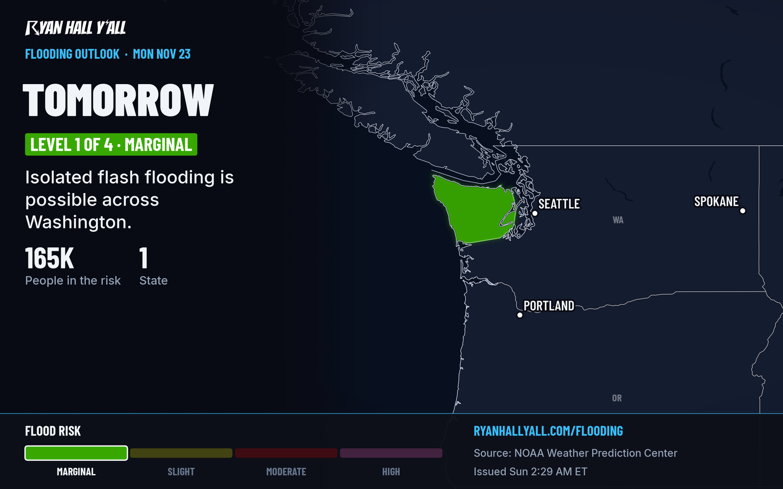
Snow showers hit the Olympics and the Cascades above 3,000 feet today. Monday brings a brief break, then a strong flow of Pacific moisture. Rain on the Olympic Peninsula could fall at half an inch an hour or more and total around 3 inches in the mountains. That is a Level 1 of 4 (Marginal) flood risk, and it matters most for burn scars and the Skokomish River. Check pass conditions before any mountain drive. See the flash flood outlook for Tuesday's Marginal risks in California, Washington and Florida.
Where the weather is good
The best weather today is a strip of southwestern Alabama and southern Mississippi, with light wind, dry air and mostly sunny skies. Much of the rest of the country is cool and cloudy. Monday, the best air shifts to southeastern Arizona.
Looking ahead
The bigger event is the holiday storm. A strong coastal low is expected to form near the Outer Banks around Thursday, Nov. 26, with heavy rain, strong winds and high surf along the East Coast. Some wintry weather is possible from the central Appalachians into the interior Northeast. How much rain, and how far inland it reaches, is still unsettled. Our Nor'easter desk story covers the track question. The West Coast stays wet through the holiday weekend, and San Francisco has a high ocean level concern Wednesday.
Bottom line
Plan on a wet Sunday evening from New Jersey to Maine, and don't drive through water on the road in southern New England or deep South Texas. If you fly or drive for Thanksgiving, start watching the East Coast storm now.
More on Mid-Atlantic flooding, November 2026
Places in this story: Corpus Christi, TX; Brownsville, TX
Sources
- WPC Day 1 Excessive Rainfall Outlook, NOAA Weather Prediction Center, issued
- WPC Day 2 Excessive Rainfall Outlook, NOAA Weather Prediction Center, issued