Forecasts
Severe thunderstorm watch in Indiana and Kentucky until 11 PM ET; Northeast rain Thursday
By Ryan Hall, Y'all Weather Desk · Published
Written by our automated news desk from National Weather Service data.
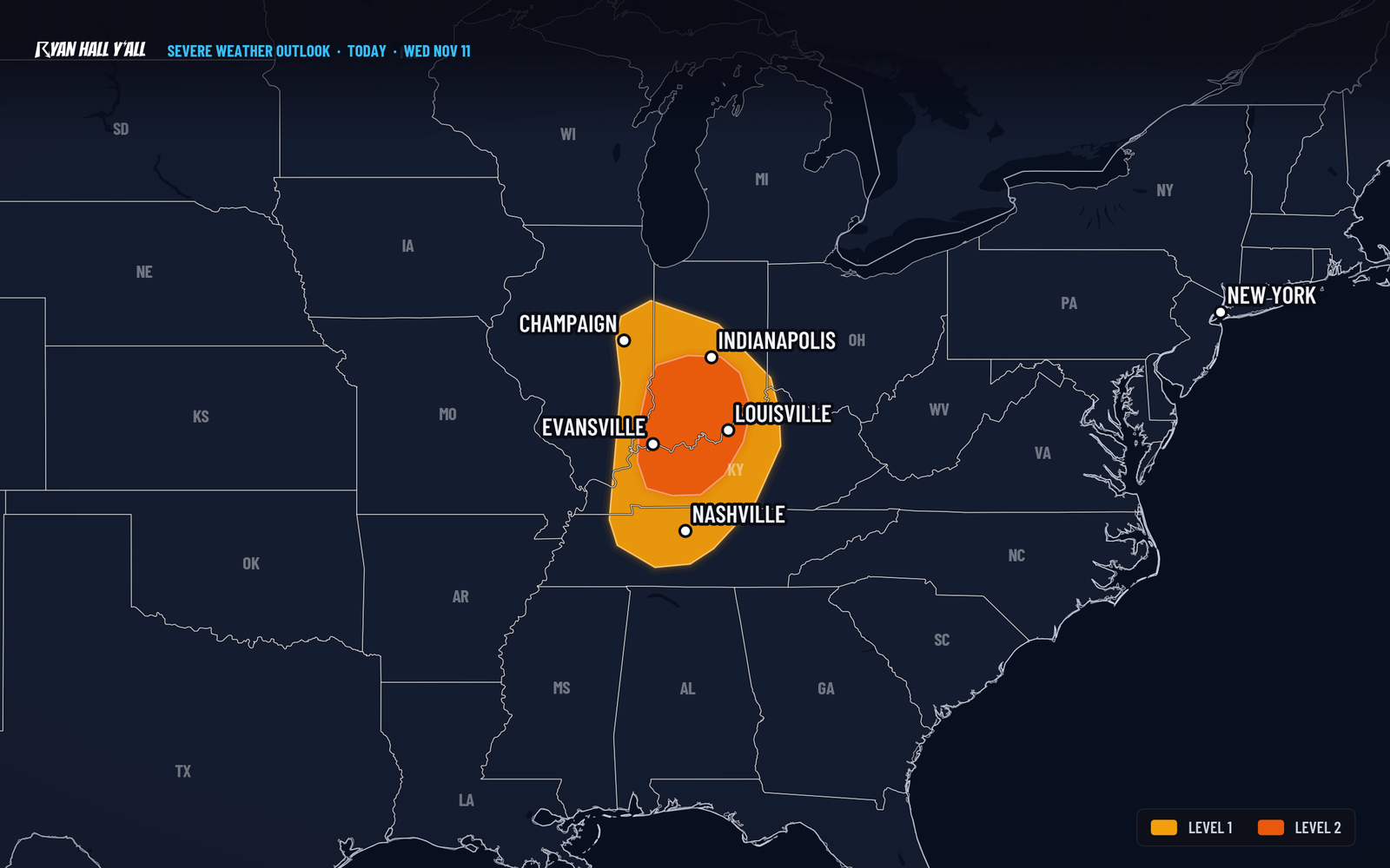
What's new: The severe risk for Indiana, Kentucky and southeastern Illinois went up from Level 1 to Level 2 of 5, and watches and warnings are now in effect.
Key points
- Indiana, western Kentucky, far southeastern Illinois, through 11 PM ET tonight: Scattered damaging wind and hail. Louisville, Evansville, Bowling Green, Bloomington and Terre Haute are in the Level 2 zone. Stay near sturdy shelter while warnings are up.
- Nashville, Indianapolis, Lafayette, Champaign, this evening: Level 1 of 5 (Marginal Risk). An isolated strong storm is possible, then a sharp drop in temperature behind the front.
- Philadelphia to New York City, Thursday afternoon, Nov. 12: Level 1 of 5. Gusts of 60 mph or higher and quarter-size hail are possible in one or two storms. Most places just get a long, gray, windy rain.
- Michigan's Upper Peninsula, starting late tonight into Saturday: Lake-effect snow, with a better than 70% chance of 4 inches or more in the Huron Mountains.
- Sierra Nevada and the West Coast, Friday, Nov. 13: Heavy rain, strong wind and blizzard conditions in the Sierra Nevada.
A line of strong thunderstorms is crossing Indiana, western Kentucky and far southeastern Illinois tonight, Wednesday, Nov. 11, with a risk of damaging gusts to 60 mph or higher and hail up to about 1.5 inches. The Storm Prediction Center raised the risk to Level 2 of 5 (Slight Risk) this afternoon, up from the Level 1 we had this morning, and a Severe Thunderstorm Watch for Indiana and Kentucky runs until 11 PM Eastern (10 PM Central). On Thursday, Nov. 12, the action moves east, with steady rain and wind from the Mid-Atlantic to New England and a few strong storms possible from Philadelphia to New York City.
Severe storms in the Ohio Valley are happening now
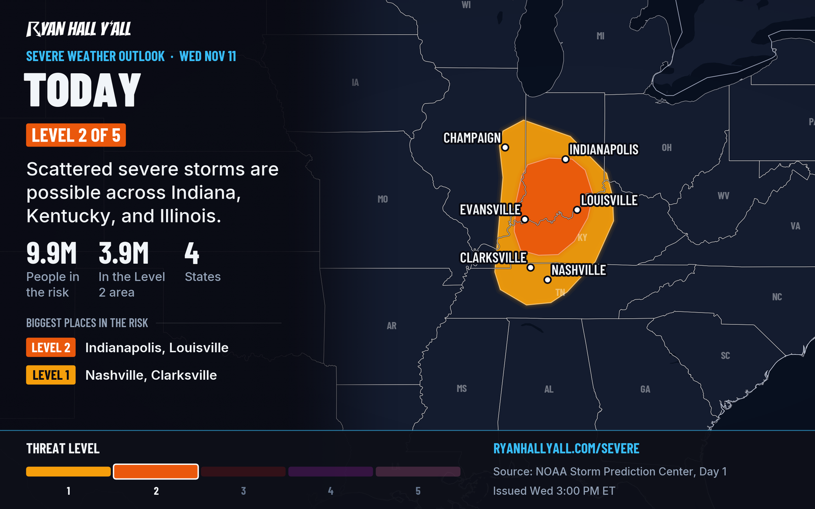
Several Severe Thunderstorm Warnings were active as of this writing. Check live warnings for your county. A cold front is moving through the region. Storm fuel of 500 to 1,000 J/kg of CAPE can support organized clusters, and a few may rotate. Damaging wind and hail are the main threats. The tornado risk is small, about 2%, but a brief spin-up is not off the table. Our desk covered the rotating wall cloud south of Terre Haute earlier, and the watch details are here.
What to do: move cars under cover if hail is in your area, and charge phones. Storms should weaken late this evening. The front is the main story after that. Temperatures fall fast, and Nashville drops from 73 to 28 by Saturday night. Exactly which towns get a severe storm is uncertain, since only some storms will turn severe.
Thursday's coastal storm brings rain, wind and a low severe risk to the I-95 corridor
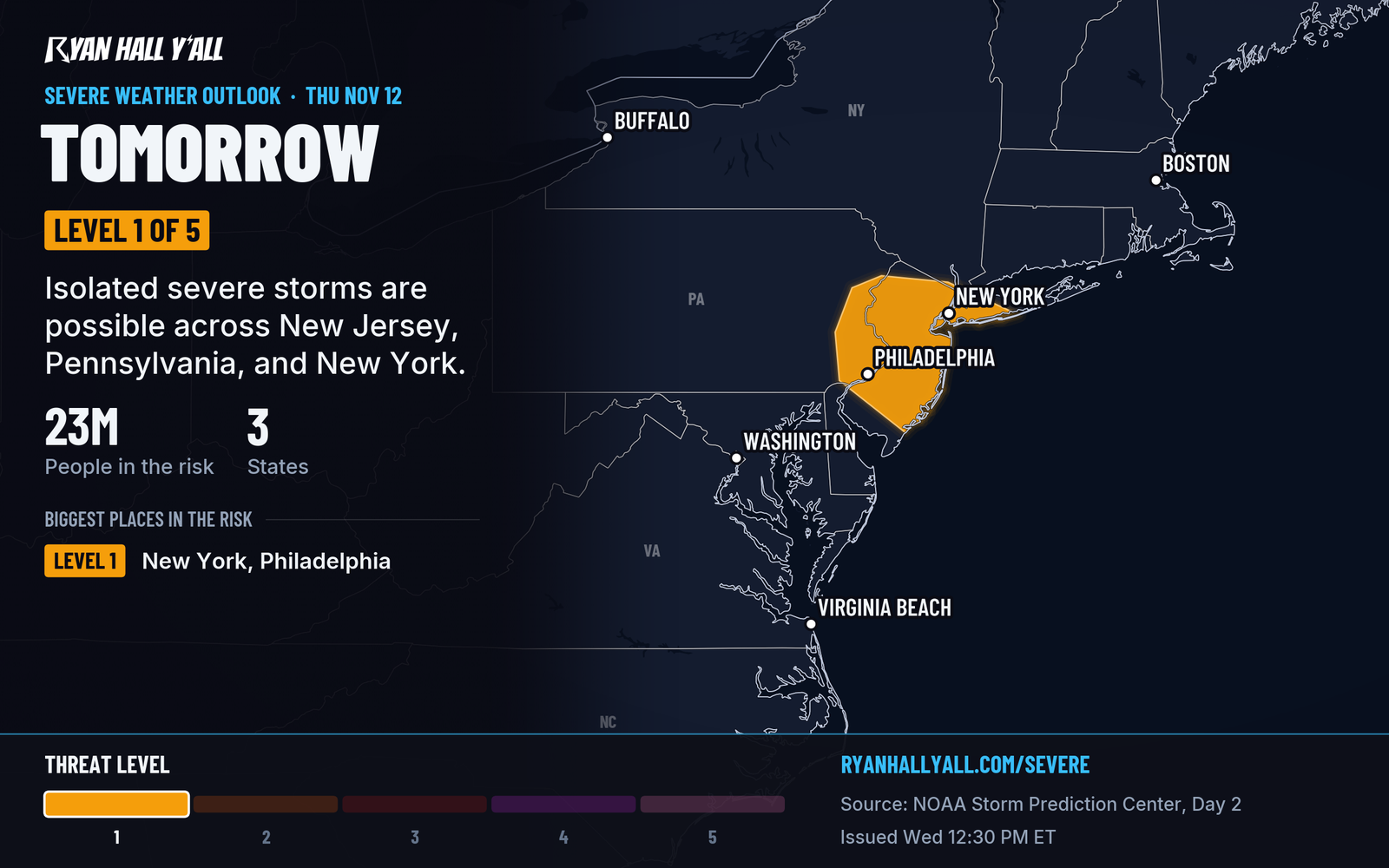
A low-pressure system crosses the Mid-Atlantic on Thursday, then strengthens off the New Jersey coast and tracks near Cape Cod. Expect a prolonged rain across the Northeast from Thursday into Friday. Over 23 million people live in the Level 1 area, but cloud cover and cool air limit the fuel for storms, so only one or two cells should turn severe, mainly in the afternoon. Our earlier Mid-Atlantic post has the full setup.
Gusty wind and minor coastal flooding are possible around high tide near New York City. Allow extra time for the Thursday evening commute. No flash flood risk is outlined, but a clogged storm drain can still flood a street in a downpour.
As colder air wraps around the storm, rain turns to snow Thursday night and Friday over the higher terrain of New York, northeastern Pennsylvania and northern New England. Cities along the coast stay mostly rain.
Lake-effect snow starts tonight in the Upper Peninsula
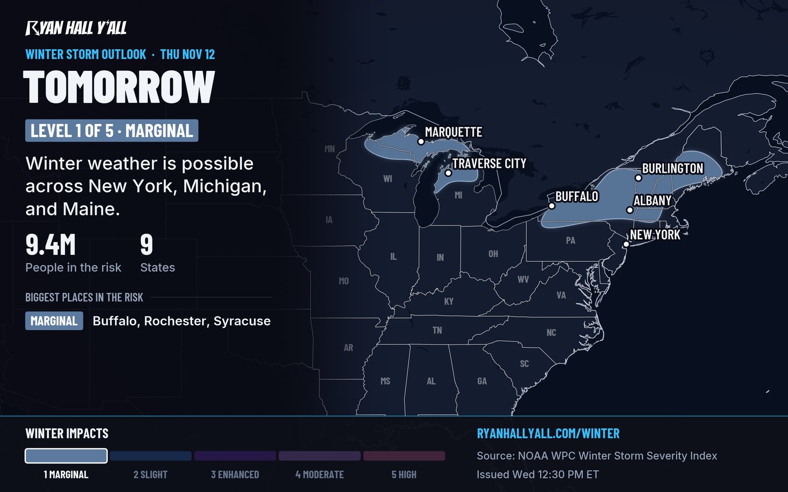
Cold northerly wind over still-mild lakes sets up bands of snow, starting late this evening in Michigan's Upper Peninsula and lasting into Saturday. The Huron Mountains have a better than 70% chance of 4 inches or more. Lighter snow reaches much of the rest of the Upper Peninsula and northern Lower Michigan. Wind down the length of Lake Michigan could also send a band of rain and wet snow into northwestern Indiana Thursday evening into Friday. Chances of 4 inches there run about 30 to 60%, and temperatures are borderline, so that one is uncertain. See our winter storm outlook for updates.
Other things to watch
- South Florida: A Level 1 of 4 (Marginal Risk) for flash flooding runs through tonight. A cell or two could drop 2 to 3 inches in the urban corridor and flood poorly drained streets.
- Southeast fire weather, Thursday: Dry, gusty northwest wind (gusts near 30 mph) behind the front raises the fire danger from the Florida Panhandle across Georgia into southwestern South Carolina. Skip outdoor burning.
- West Coast: A Coastal Flood Advisory covers the San Francisco Bay shoreline until 4 PM Friday, with up to 1.5 feet of water over low-lying ground near the shore. A strong Pacific storm arrives Friday.
- Tropical Storm Pena: It has 45 mph winds in the open Central Pacific, moving west, and it threatens no land.
Bottom line
Tonight's job is the Ohio Valley line, which should fade by around 11 PM Eastern. After that, the story moves east for a wet, windy Thursday from Philadelphia to Boston. Sign up for Y'all Alerts so a warning reaches your phone before you go to bed.
More on Ohio Valley severe weather, November 2026
Places in this story: Philadelphia, PA; New York City, NY; Louisville, KY; Evansville, IN; Nashville, TN; Indianapolis, IN
Sources
- SPC Day 1 Convective Outlook, NOAA Storm Prediction Center, issued
- SPC Day 2 Convective Outlook, NOAA Storm Prediction Center, issued
- Ryan Hall, Y'all winter storm outlook, day 2 (our own outlook), Ryan Hall, Y'all, issued
- WPC Winter Storm Severity Index (WSSI), NOAA Weather Prediction Center