Forecasts
Coldest air of the season Wednesday night; Northeast coastal storm Thursday
By Ryan Hall, Y'all Weather Desk · Published
Written by our automated news desk from National Weather Service data.
What's new: Cold air and Thursday's coastal storm now lead; the Level 1 Ohio Valley storm risk is unchanged from last night.

Key points
- Central and eastern U.S., Wednesday night into Thursday: the coldest air so far this season arrives behind a cold front, and the first widespread frost or freeze is likely across the interior South, Tennessee Valley, Ohio Valley and interior Mid-Atlantic. Cover or bring in tender plants.
- Baltimore to Boston, Thursday, Nov. 12: a coastal low brings rain, strong coastal winds and a risk of minor coastal flooding around high tide. Expect airport delays.
- Upper Peninsula of Michigan and the Great Lakes, Wednesday into Friday: lake-effect snow, heaviest in the Huron Mountains, with a Marginal winter weather risk. Roads can get slick in a hurry.
- Nashville, Louisville, Evansville, Indianapolis, this afternoon and evening: isolated storms may produce damaging gusts of 60 mph or more, quarter-size hail and perhaps a tornado.
- Washington state and Northern California, Thursday into the weekend: a Pacific storm brings heavy rain, mountain snow and gusty winds.
The coldest air of the season so far sweeps across the central and eastern U.S. beginning Wednesday night, Nov. 11. On Thursday, Nov. 12, a strengthening coastal low brings wind and rain from the Mid-Atlantic through New York and New England. It also brings wet snow to the higher ground of interior New England. Today's storm threat in the Ohio and Tennessee Valleys is a Level 1 of 5 (Marginal) risk.
A coastal low brings wind, rain and wet snow to the Northeast Thursday
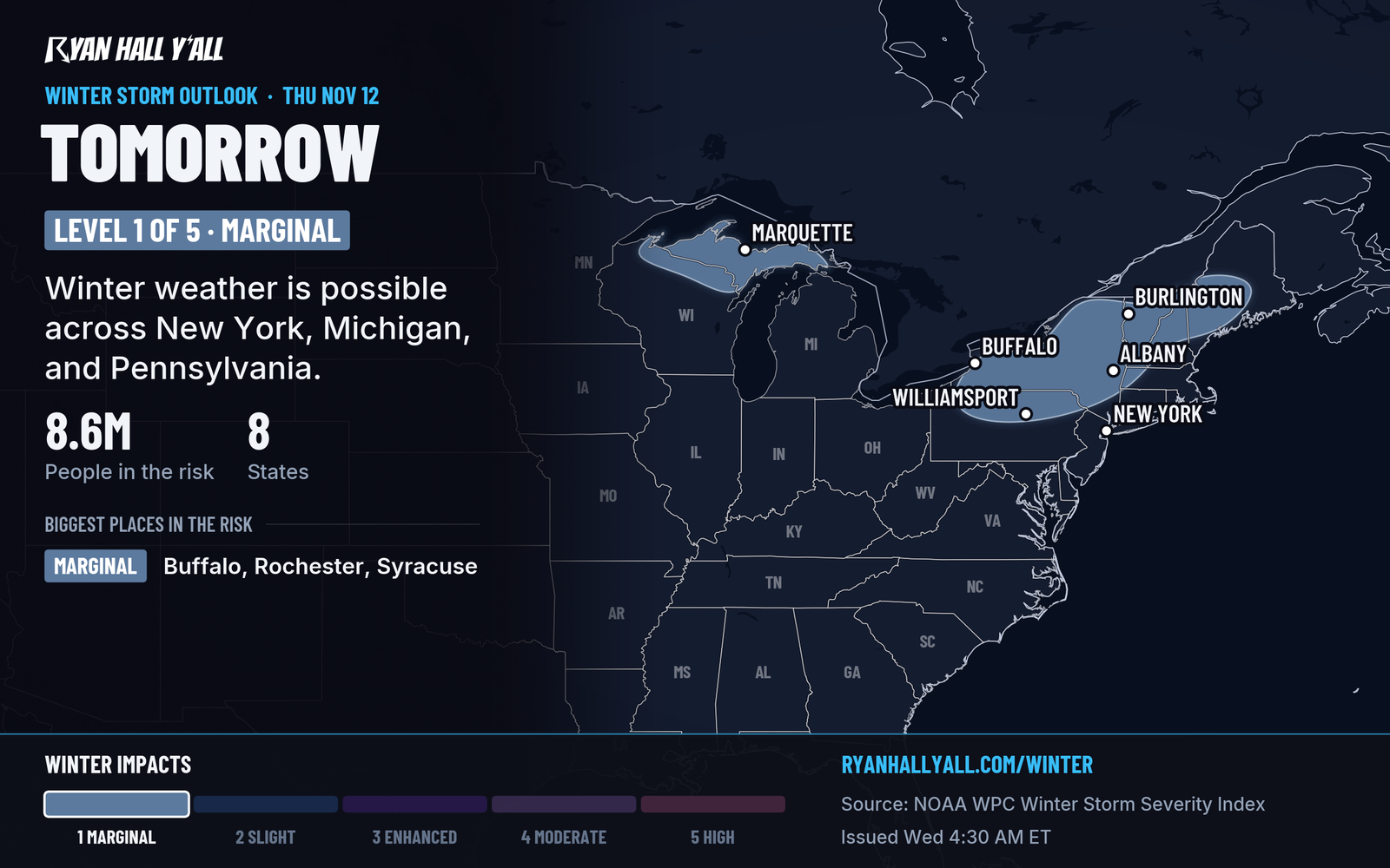
The cold front and a deepening upper-level dip in the jet stream set this up. A low strengthens near the Mid-Atlantic coast on Thursday. Rain spreads north through Washington and Baltimore, New York City and coastal New England, and winds turn gusty along the coast. Around high tide, minor coastal flooding is possible.
Farther inland, the cold air wraps in behind the low. Rain changes to wet snow at higher elevations. That means northern New England, the Adirondacks, western Maryland and the central and southern Appalachians. Our winter storm outlook has a Marginal risk of winter weather impacts for the higher terrain of the Northeast and central Appalachians Thursday. The risk continues Friday for the interior Northeast and central Appalachians. Valley towns will mostly see rain, so the snow question is about elevation.
How sure are we? That a storm forms and the cold arrives is solid. The exact track near the Mid-Atlantic coast is still uncertain, and that decides how much rain and wind Baltimore and Washington get, and where the rain-to-snow line sets up. Our airport delay outlook points to ground delays and cancellations at JFK, Newark and Boston on Thursday. If you fly out of the Northeast, check your flight first.
The low then moves off New England Friday, with mountain snow followed by a drier weekend. We covered that in Low off New England Friday, Nov. 13 means mountain snow, then a dry weekend.
Lake-effect snow for the Upper Peninsula and the Great Lakes
Northerly wind blows across lakes that are still mild. Lake Superior's surface is roughly 8 to 12 degrees Celsius, and Lake Michigan's roughly 10 to 15. That temperature gap squeezes out snow bands. Michigan's Upper Peninsula, especially the Huron Mountains, gets the most. Chicago's O'Hare and Midway may see low clouds Thursday. Check the winter storm outlook before driving across the north woods.
Isolated storms in Nashville, Louisville and Indianapolis this afternoon
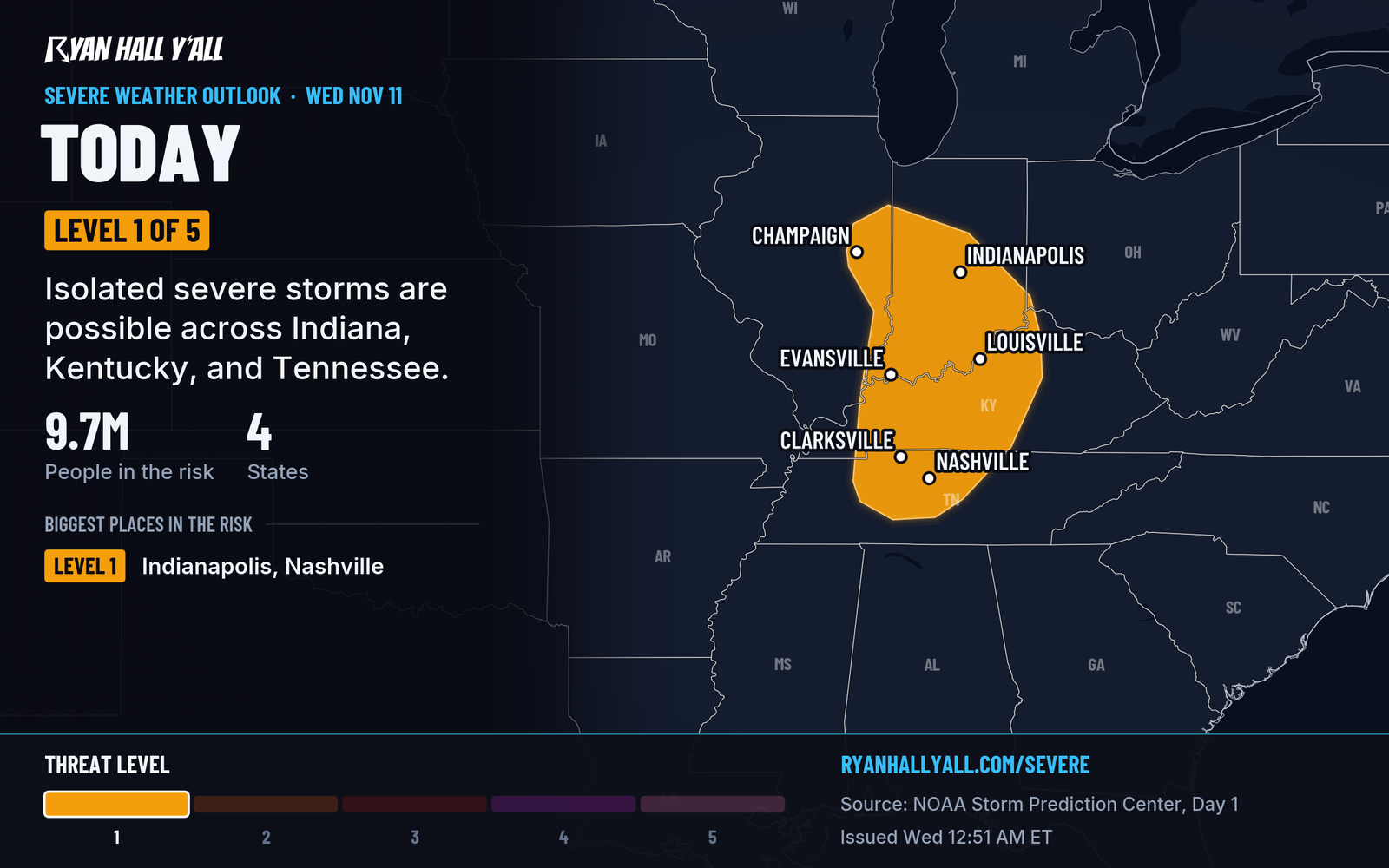
Storms fire along the cold front from this afternoon into the evening, across Indiana, Kentucky, Tennessee and Illinois. That is a Level 1 of 5 (Marginal) risk for about 9.6 million people. Isolated damaging gusts of 60 mph or more and quarter-size hail are possible, and a 2% tornado area covers part of the risk. Have a way to get a warning, and check the severe outlook before an evening drive. The Level 1 risk is unchanged from last night.
Unseasonable warmth in the West, then a wet Pacific storm
Unseasonable warmth holds across much of the West, and a few daily record highs are possible in parts of the Northwest and Great Basin. A stronger Pacific storm follows. It pushes an atmospheric river into the northern Sierra Nevada, with heavy mountain snow and tough pass travel. Western Washington gets heavy rain, mountain snow and potentially damaging winds. More rounds of rain and mountain snow are likely from California to Washington through the weekend and into next week.
Where the weather is great
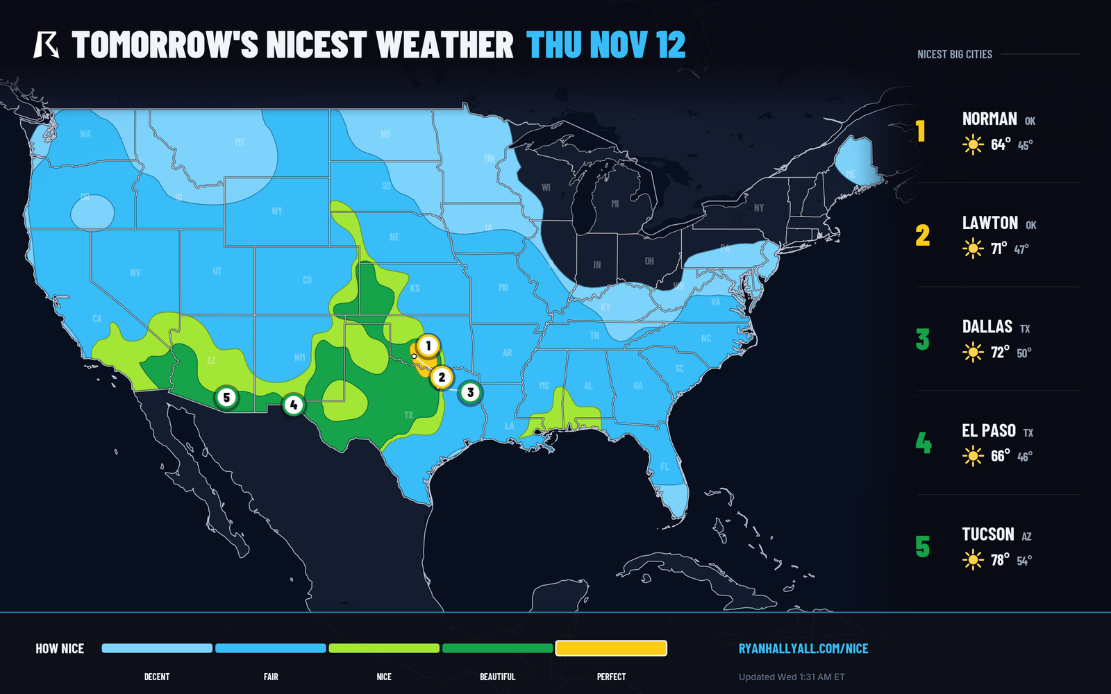
The best weather today is in southern New Mexico, southern Nevada, southeastern Arizona and west and southwest Texas, rated Beautiful. Thursday's best is southern Oklahoma and north-central Texas, rated Perfect. See the Nice Weather outlook.
Looking ahead
Friday brings dry, cool air to the South, with a Beautiful-rated pocket from southern Texas through Louisiana and central Mississippi. Saturday, much of the Plains and East stays chilly, with highs near 50 and lows in the mid-30s. Late Saturday into Sunday, thunderstorms with an isolated severe threat are possible across south and central Texas. Tropical Storm Pena in the central Pacific, with 46 mph winds, is moving west with no coastal watches or warnings and no landfall forecast.
Bottom line
Get ready for the first widespread frost or freeze of the season Wednesday night, and protect tender plants. If you are in the Northeast, plan for a wet, windy Thursday, and allow extra time for flights.
More on Weather records, November 2026
Places in this story: Nashville, TN; Louisville, KY; Indianapolis, IN; Baltimore, MD; Evansville, IN
Sources
- SPC Day 1 Convective Outlook, NOAA Storm Prediction Center, issued
- Ryan Hall, Y'all winter storm outlook, day 2 (our own outlook), Ryan Hall, Y'all, issued
- WPC Winter Storm Severity Index (WSSI), NOAA Weather Prediction Center
- Ryan Hall, Y'all Nice Weather outlook (our own outlook), Ryan Hall, Y'all, issued