Forecasts
Texas coast flood risk widens to Corpus Christi and Matagorda Bay Sunday, Nov. 15
By Ryan Hall, Y'all Weather Desk · Published
Written by our automated news desk from National Weather Service data.
What's new: The Level 2 of 4 flash flood risk for Sunday was expanded south and west through Corpus Christi and Matagorda Bay, and the heaviest rain axis shifted to between Houston and Corpus Christi.

Key points
- Texas coast, Sunday: Heavy rain from Corpus Christi to Houston. Pockets of 3 to 5 inches are possible under repeating storms. Avoid water over the road, especially in cities and on low-lying streets.
- Central and south Texas, Sunday afternoon and evening: A few strong storms with hail or gusty wind. A brief tornado is possible but unlikely. Level 1 of 5 (Marginal).
- North-central Texas, tonight: Storms and rain move east and southeast from the Panhandle overnight. Lubbock and the South Plains could see quarter-size hail this evening.
- Oregon coast, until 1 AM PST Sunday: South winds 25 to 35 mph with gusts to 60 mph, including exposed stretches of Highway 101.
- Southeast, tonight: A freeze is still on for Sunday morning, as covered earlier today.
The Level 2 of 4 (Slight) flash flood risk for Sunday, Nov. 15, now stretches south and west to include Corpus Christi and Matagorda Bay, with the heaviest rain expected between Houston and Corpus Christi. Rain and storms spread over central Texas and the coast through the day, and the heaviest rain should wrap up around midnight as Sunday turns to Monday. Tonight, storms cross north-central Texas first.
The Texas coast gets the most rain Sunday
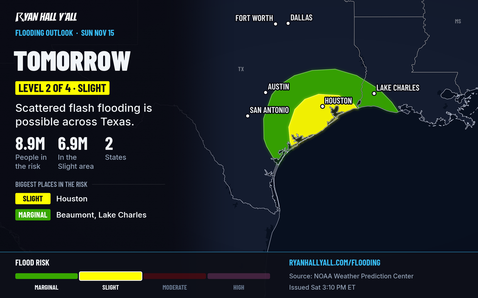
The Weather Prediction Center pushed the Slight risk area to the south and west this afternoon. The reason is a disturbance sliding southeast toward the Gulf, with low pressure forming along the western Gulf Coast. Storms should re-fire over central Texas Sunday afternoon and train over the same ground near the coast. Training means one storm after another passing over the same spot.
That is how a few places can pick up 3 to 5 inches while nearby areas get a plain wet day. Flooding should be mostly local: streets, underpasses, small creeks and low spots. If you drive Sunday on I-45 near Houston or I-37 and US-77 toward Corpus Christi, give yourself extra time and turn around at water over the road.
Exactly where the heaviest band sets up is less certain. Wind Advisories are also expected along parts of the Gulf Coast Sunday as the low develops. Our flash flood outlook has the latest map. The earlier story is here.
A few strong storms Sunday, hail and wind first
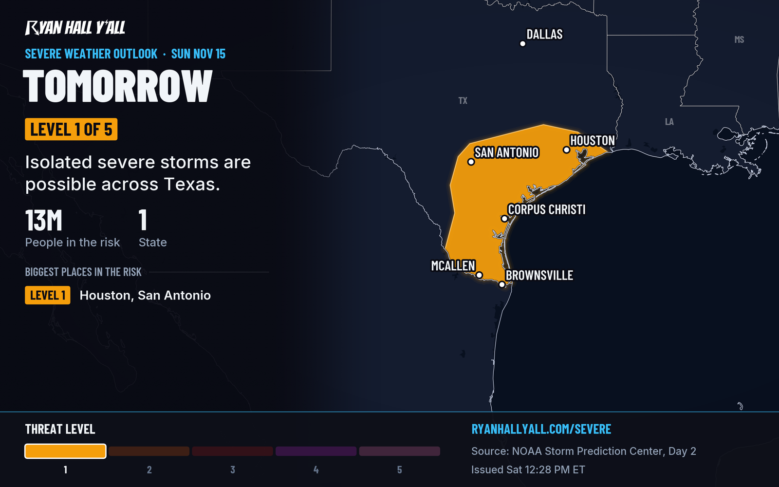
The Storm Prediction Center has a Level 1 of 5 (Marginal) risk Sunday across the Texas coastal plain and parts of central and south Texas, including Houston, San Antonio, Corpus Christi and the Rio Grande Valley. Odds are 5% for hail an inch or larger, 5% for damaging gusts of 60 mph or more, and 2% for a tornado. Storms may organize into clusters or a linear segment in the afternoon and evening. The strongest fuel then shifts toward the coast and offshore, so the inland threat fades late in the day. Keep a weather radio or phone alerts on. See the severe outlook for updates.
Tonight: storms from the Panhandle to north-central Texas
A front is parked over the South Plains. Storms should build there from about 4 PM Central and drift east and southeast overnight. Most will sit above the cold air at the surface, so hail is the main worry, with quarter-size hail possible. Lubbock and Lamesa are in the Level 1 area. The rain across north-central Texas is mostly welcome on dry ground, though a small chance of locally 1 to 2 inches carries a Marginal flood risk.
The West Coast storm is still churning
A Pacific storm is sending big surf onto the coast. A High Surf Warning along Pacific Coast beaches calls for 25 to 35 foot breaking waves, with sets of 40 to 50 feet at some spots, until 4 AM PST Sunday. Stay off jetties and beach rocks. Mason County, Washington, is under a Flood Watch through Sunday morning. Colder air then drops snow levels in the Cascades and Sierra. Heavy Sierra snow is expected Sunday night into Monday, with travel trouble likely near Donner Pass on I-80. Active warnings are listed live.
Northeast snow ends by midday, and the freeze is on
Spotty snow above about 1,000 feet falls tonight on the Southern Tier of New York, the Catskills, the Adirondacks and the Green and White Mountains. Most spots get a coating to 2 inches, with up to 3 inches in the highest terrain. It ends by midday Sunday. The Southeast freeze Sunday morning is in our earlier story.
Bottom line
Sunday's flood threat is the main event, and it now covers more of the Texas coast than it did this morning. Plan your drives around Corpus Christi, Houston and the stretch between them, and don't test water over a road.
More on Texas flooding, November 2026
Places in this story: Corpus Christi, TX; Houston, TX; Lubbock, TX
Sources
- SPC Day 2 Convective Outlook, NOAA Storm Prediction Center, issued
- WPC Day 2 Excessive Rainfall Outlook, NOAA Weather Prediction Center, issued