Weather news
113 years ago today, the White Hurricane sank eight ships on Lake Huron
By Ryan Hall, Y'all Weather Desk · Published · Updated
Written by our automated news desk from National Weather Service data.
What's new: Added our Lake Huron graphic comparing last night's gale zone with the 1913 storm; refreshed frost and South Texas rain details
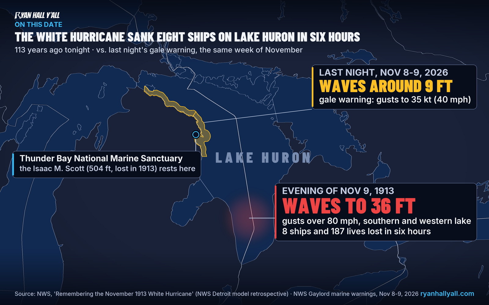
The evening of November 9, 1913 was the worst stretch of the deadliest storm in Great Lakes history, with gusts over 80 mph, 36-foot waves and eight ships lost in six hours. Last night's gale warning covered the same water off Alpena but was far weaker. This week turns sharply colder, with lake effect rain and snow late in the week and snow in the Northeast hills.
Key points
- Where: Lake Huron, especially the southern and western parts, with the wreck of the Isaac M. Scott in Thunder Bay off Alpena, Michigan.
- When: The evening of November 9, 1913, inside a storm that ran November 7 to 10.
- What: Gusts over 80 mph and frequent waves to 36 feet. Across the whole storm, a dozen major shipwrecks and an estimated 250 lives lost.
- Today: Last night's gale on northern Lake Huron was far weaker. Colder air with lake effect rain and snow arrives Thursday into Friday.
Updated 6:45 AM ET Monday.
On the evening of November 9, 1913, hurricane-force gusts and waves up to 36 feet hit southern and western Lake Huron. Eight ships went down and 187 people died in about six hours. It was the worst stretch of the deadliest storm in Great Lakes history, and the water off Alpena, Michigan, had a gale warning out again last night.
What happened on Lake Huron that night
Two areas of low pressure merged over Lake Huron and strengthened fast. Gale warnings had gone out on November 7. Captains were still caught in winds near 90 mph and waves around 35 feet.
The numbers from a modern computer rebuild of the storm are stark. On that Sunday evening, gusts topped 80 mph and waves of 36 feet were common on southern and western Lake Huron. Eight ships and 187 lives were lost in six hours.
For the whole four-day storm, the count is a dozen major shipwrecks and an estimated 250 deaths. By number of ships lost, it is still the largest inland maritime disaster in U.S. history. Damage was put at about $6 million in 1913 money, roughly $117 million in 2013 dollars.
The Isaac M. Scott still rests in Thunder Bay
One of the lost ships was the Isaac M. Scott, a 504-foot steel freighter. It went down with 28 people aboard. Its wreck lies in Thunder Bay National Marine Sanctuary, off the Alpena area. Our graphic above pins that spot and sets last night's warning beside the 1913 numbers.
That same stretch of water was under a gale warning from 4 PM EST Sunday until 5 AM EST Monday. It covered northern Lake Huron from just east of the Mackinac Bridge down to Presque Isle and Sturgeon Point, including the sanctuary. Northwest gusts up to about 40 mph and waves around 9 feet were forecast. The warning was canceled at 3:48 AM EST. A small craft advisory stays up until 11 AM EST.
Last night's gale was a fraction of the 1913 storm. Gusts then were roughly double and waves close to four times as tall.
What the rest of this week looks like
Lake Huron is not in for another 1913. The pattern is turning colder, though.
- Thursday into Friday: A disturbance digs into the eastern U.S. and the air turns sharply colder around the Great Lakes, with lake effect rain and snow in places.
- Thursday night into Friday: A storm strengthens off the East Coast. Our winter storm outlook shows accumulating snow possible in the higher terrain of the interior Northeast, including the Adirondacks and the Green and White Mountains. Confidence in big totals is lower early on because temperatures are marginal. Rain turns to snow only as colder air filters in.
- Friday night into Saturday: Northwest winds behind that storm set up lake effect rain and snow in the Great Lakes snowbelts. Model agreement on the details is only moderate so far.
This colder turn comes at the start of the November gales season.
Other weather today
Frost advisories are up this morning for parts of Kentucky, southern Ohio and southeast Indiana, plus north Georgia, central and northern Alabama and the western North Carolina foothills. Lows run from the low to mid 30s, with the coldest spots near 33. Most advisories end by 9 or 10 AM, so protect any tender plants until then.
In South Texas, repeated heavy rain has soaked the Corpus Christi and Kingsville area. Parts of South Texas have seen 4 to 9 inches in the past day, with local totals of 5 to 10 inches near Kingsville. A Level 2 of 4 (Slight Risk) flash flood risk stays up through today, with the heaviest rain focused between Corpus Christi and Brownsville this morning. The threat should gradually decrease by late afternoon, though local flash flood impacts remain possible through this evening. Don't drive through water over the road, especially where the ground is already soaked.
What to do
- Boaters on the Great Lakes: Check marine forecasts before every trip.
- Snowbelt and Northeast mountain travelers: Watch the winter outlook for Thursday night through Saturday. Accumulating snow is possible in the higher terrain of the interior Northeast.
- South Texas drivers: Skip flooded roads this morning, and give yourself extra time near Corpus Christi.
- Everyone: Keep an eye on active warnings near you, or get free Y'all Alerts on your phone.
Bottom line
The White Hurricane killed 187 people in six hours on Lake Huron, and the wreck of one of its victims lies in water that had a gale warning last night. This week's Great Lakes weather is only a colder, windier November pattern, but it is the season that storm made famous.
Explained: Lake-effect snow: what it is, why it falls in bands, and what the alerts mean
More on 2026 hurricane season
Sources
- NWS, 'Remembering the November 1913 White Hurricane', National Weather Service, issued
- same NWS page, from NWS Detroit's numerical model retrospective (posted Nov 7, 2013), National Weather Service
- same NWS page (posted Nov 7, 2013), National Weather Service
- NWS Gaylord Marine Weather Messages (MWWAPX) (4:04 AM EST Nov 8 through 3:48 AM EST Nov 9, 2026), National Weather Service
- NWS Gaylord Area Forecast Discussion, key messages (2:42 AM EST Nov 9, 2026), National Weather Service
https://ryanhallyall.com/news/113-years-ago-today-the-white-hurricane-sank-eight-ships-on-lake-huron