Forecasts
New England Level 2 flash flood risk removed; South Texas Level 2 until dawn
By Ryan Hall, Y'all Weather Desk · Published
Written by our automated news desk from National Weather Service data.
What's new: The Level 2 flash flood risk in the Northeast was removed and the Marginal area was cut back to coastal New England and northern Maine; South Texas stays at Level 2 of 4.

Key points
- New England coast, tonight through Monday morning: Moderate to heavy rain, gusty wind and fog. Leave extra time Monday morning for ponding on roads.
- South Texas, until about 6 AM Central Monday: Level 2 of 4 for flash flooding, plus a Level 1 of 5 (Marginal) chance of a storm with quarter-size hail. Don't drive through water over the road tonight.
- Oklahoma, Texas, New Mexico and Arizona, Monday morning: Freezes, hard in spots. Cover plants and protect pipes tonight.
- Michigan's Upper Peninsula and northern Wisconsin, late tonight through Monday afternoon: Lake-effect snow, 3 to 6 inches in the snowbelts. Visibility can drop fast under the heavy bands.
- Northeast Florida, tonight: River and tidal flooding continues along the St. Johns River, with more downpours Monday.
The Level 2 flash flood risk in New England was removed, leaving a Level 1 of 4 (Marginal) risk along coastal New England and northern Maine tonight into Monday morning. Moderate to locally heavy rain spreads across New England tonight and lasts into Monday morning, with street flooding possible on the Monday commute from Providence to Boston to coastal Maine. In South Texas, a Level 2 of 4 (Slight) flash flood risk holds until about 6 AM Central Monday around Corpus Christi, Brownsville and McAllen.
New England rain: less flooding risk, still a wet Monday commute
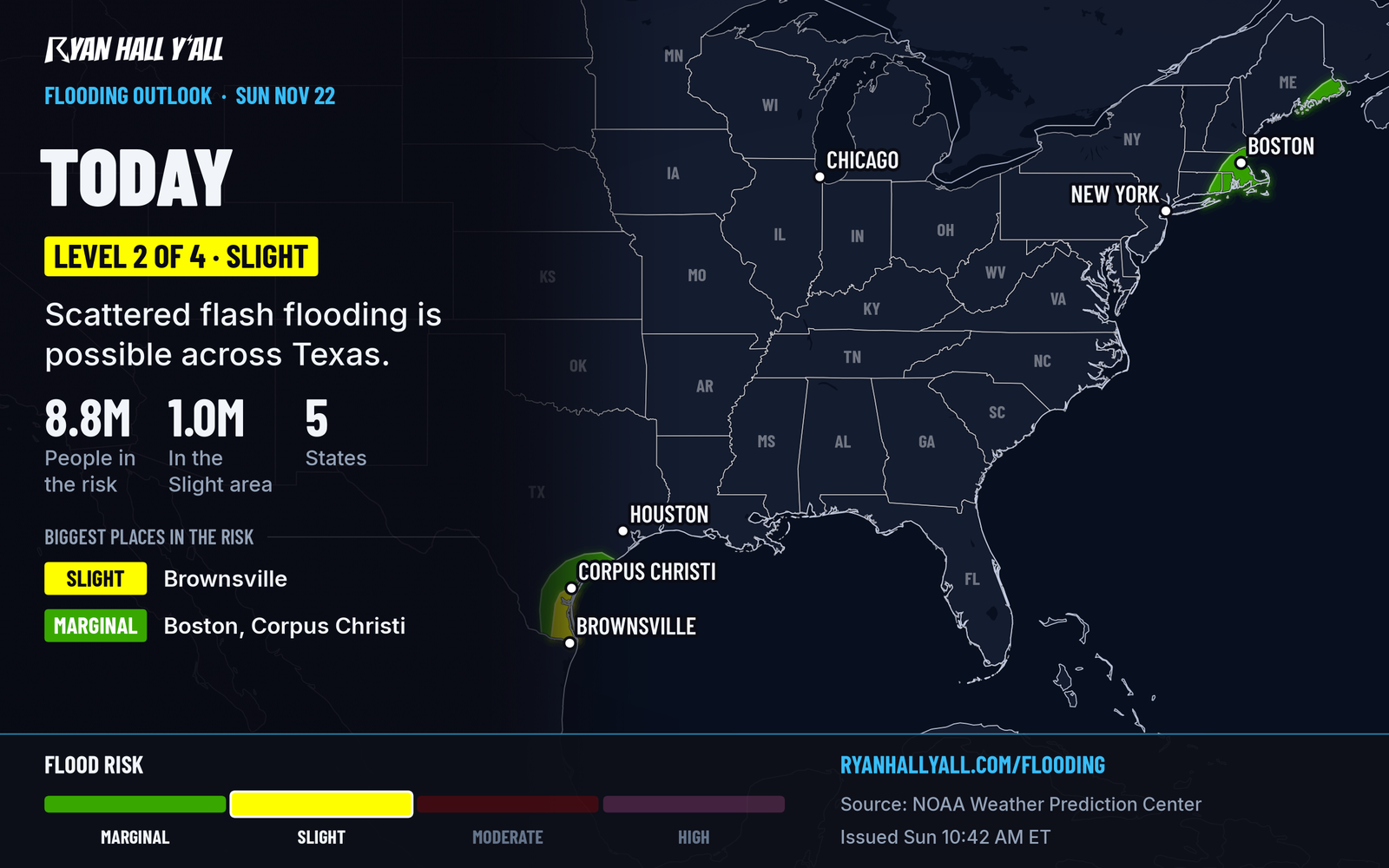
A coastal low passes east of the New Jersey shore tonight and crosses the Gulf of Maine on Monday. Rain spreads over New England tonight, with the heaviest totals along the coastal plain. The Level 2 flash flood risk we flagged this morning is gone. The core of the heaviest rain is now trending offshore, and the ground there can take a lot of rain before it floods. A Level 1 of 4 (Marginal) risk remains for coastal New England and northern Maine.
Expect ponding and nuisance street flooding in places, mainly on the Monday morning commute. Fog is already cutting visibility at Boston, Providence and Portland, Maine, so expect delays that can ripple into other airports. Check the airport delay outlook before you leave. Rain tapers off from west to east Monday afternoon as drier air moves in. Northern New England and Maine need this rain because of the ongoing drought.
High tides ahead of Tuesday's full moon, plus big waves, may cause minor coastal flooding along the Mid-Atlantic and Southeast coasts. Beach erosion and ocean overwash are possible on the Outer Banks. The bigger storm is Thursday, Nov. 26, which we covered in 1 to 2 inches of rain, strong wind on I-95 Thanksgiving Day. That track is still not locked in.
South Texas: flooding risk lasts until the front clears
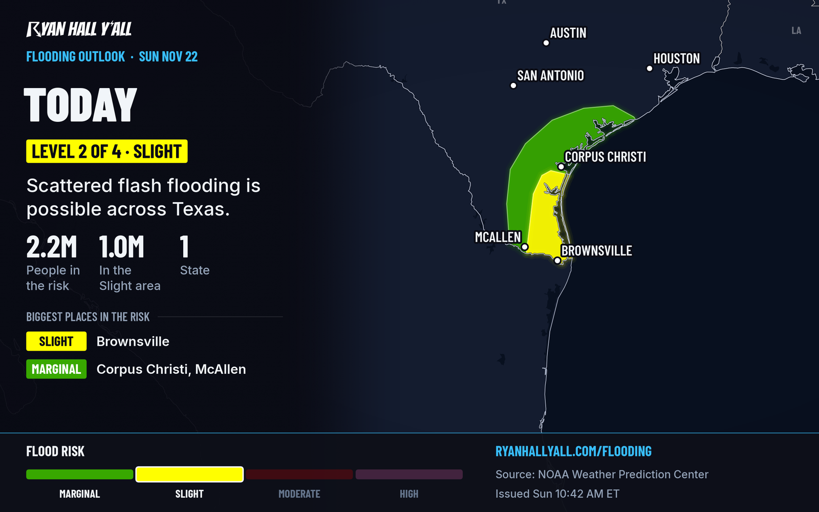
Level 2 of 4 covers South Texas through about 6 AM Central Monday. Flood and coastal flood advisories are already out near Corpus Christi and Aransas County, and the coastal flood advisory runs until 6 AM Central Monday. A few storms could also produce quarter-size hail tonight. Once the cold front moves offshore Monday, the threat ends. Plan any late drive around low-lying roads and underpasses. Water over a road means turn around.
Hard freeze Monday morning, lake-effect snow in the north
Much colder air arrives behind that front. Parts of Texas may see the season's first freeze Monday or Tuesday, and hard freezes are possible across Oklahoma, New Mexico and Arizona. Bring in pets, cover tender plants and drip faucets on exposed pipes.
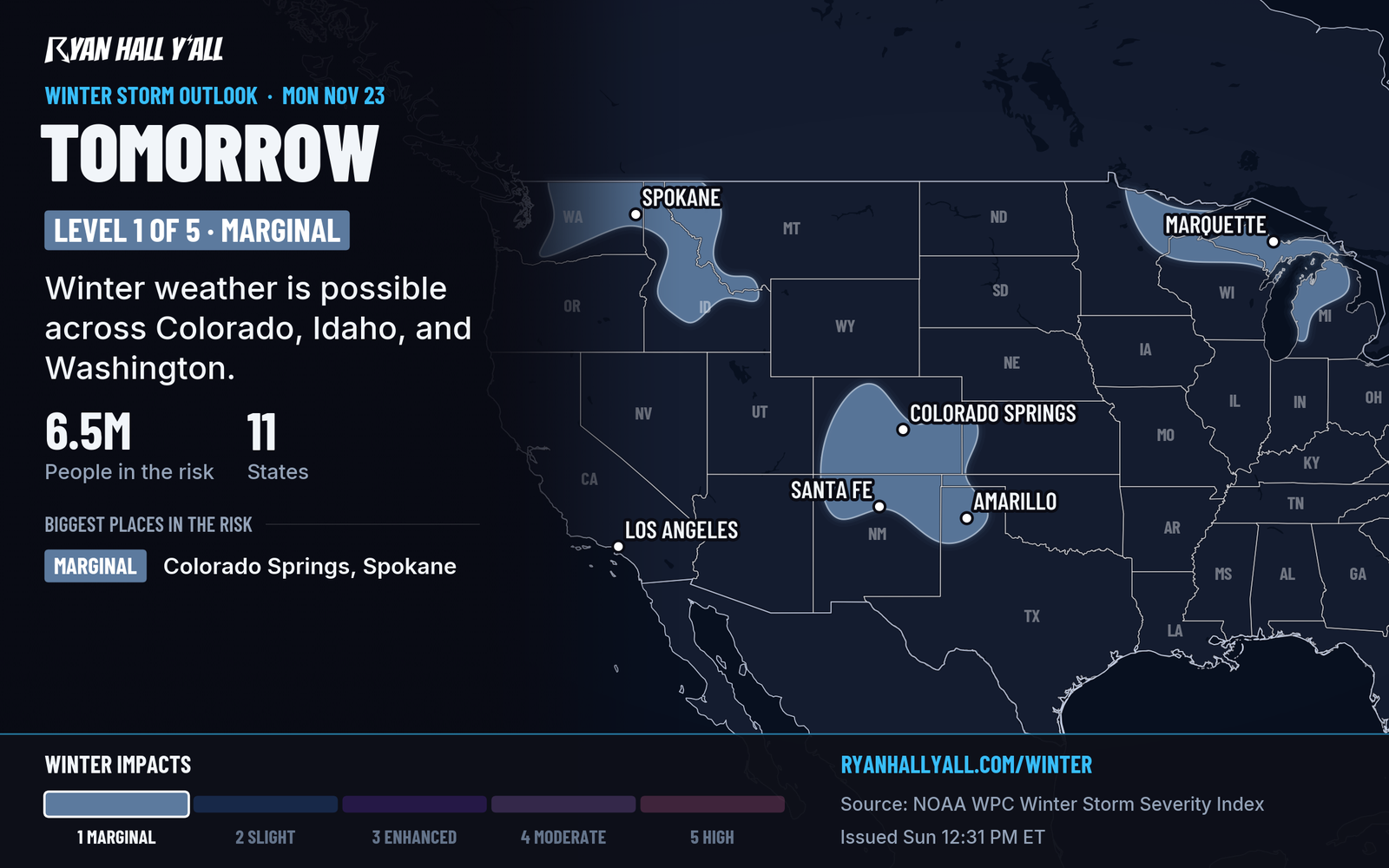
Our winter storm outlook has a Marginal risk of winter weather impacts Monday across the southern High Plains, upper Great Lakes and Pacific Northwest. Light snow or a wintry mix could reach New Mexico and the southern High Plains Monday night. Cold northwest wind over Lake Superior sets up the lake-effect bands, with locally higher totals in the Porcupine and Huron Mountains.
Florida and the West Coast: water keeps rising
A flood warning continues for the St. Johns River near Sanford, with moderate flooding and no end date. A coastal flood warning covers the St. Johns River Basin until 5 AM Eastern Monday, and a coastal flood advisory covers Duval County, which includes Jacksonville. Monday brings scattered showers and storms across the Florida Peninsula, mostly not severe, but with heavy downpours that can add to urban flooding.
On the West Coast, coastal flood warnings start Monday at 6 AM Pacific around San Francisco Bay, where water could reach up to 2.8 feet above ground in low spots. Warnings start Tuesday at 4 AM Pacific for the San Diego and Orange County coast and for the Oregon and southern Washington coast. Our desk story has the details: West Coast seas run 1 foot high; San Diego tide record likely falls Tue-Wed. Check the live warnings page for your county.
Bottom line
New England gets a soggy night and a wet Monday commute, but the flash flood threat has eased. South Texas has to get through the night before the front clears it out, and the cold air behind it means freeze protection from Oklahoma to the Southwest by Monday morning.
More on South Texas flooding, November 2026
Places in this story: Providence, RI; Boston, MA
Sources
- WPC Day 1 Excessive Rainfall Outlook, NOAA Weather Prediction Center, issued
- Ryan Hall, Y'all winter storm outlook, day 2 (our own outlook), Ryan Hall, Y'all, issued
- WPC Winter Storm Severity Index (WSSI), NOAA Weather Prediction Center