Weather news
October ranked 4th warmest on record for the Lower 48, 4+ degrees above normal
By Ryan Hall, Y'all Weather Desk · Published
Written by our automated news desk from National Weather Service data.
Key points
- What: October was the 4th warmest on record across the Lower 48, more than 4 degrees above normal, per NOAA's national climate report released Monday.
- Where: The national ranking covers the Lower 48. State ranks vary, and our map lets you find yours.
- Right now: Heavy rain is still soaking South Texas around Corpus Christi, with a Level 2 of 4 (Slight Risk) for flash flooding today.
- What's next: A cooler, drier air mass is expected over much of the country this weekend into early next week, with wet snow in the higher terrain of the Appalachians and Northeast late Thursday into Friday.
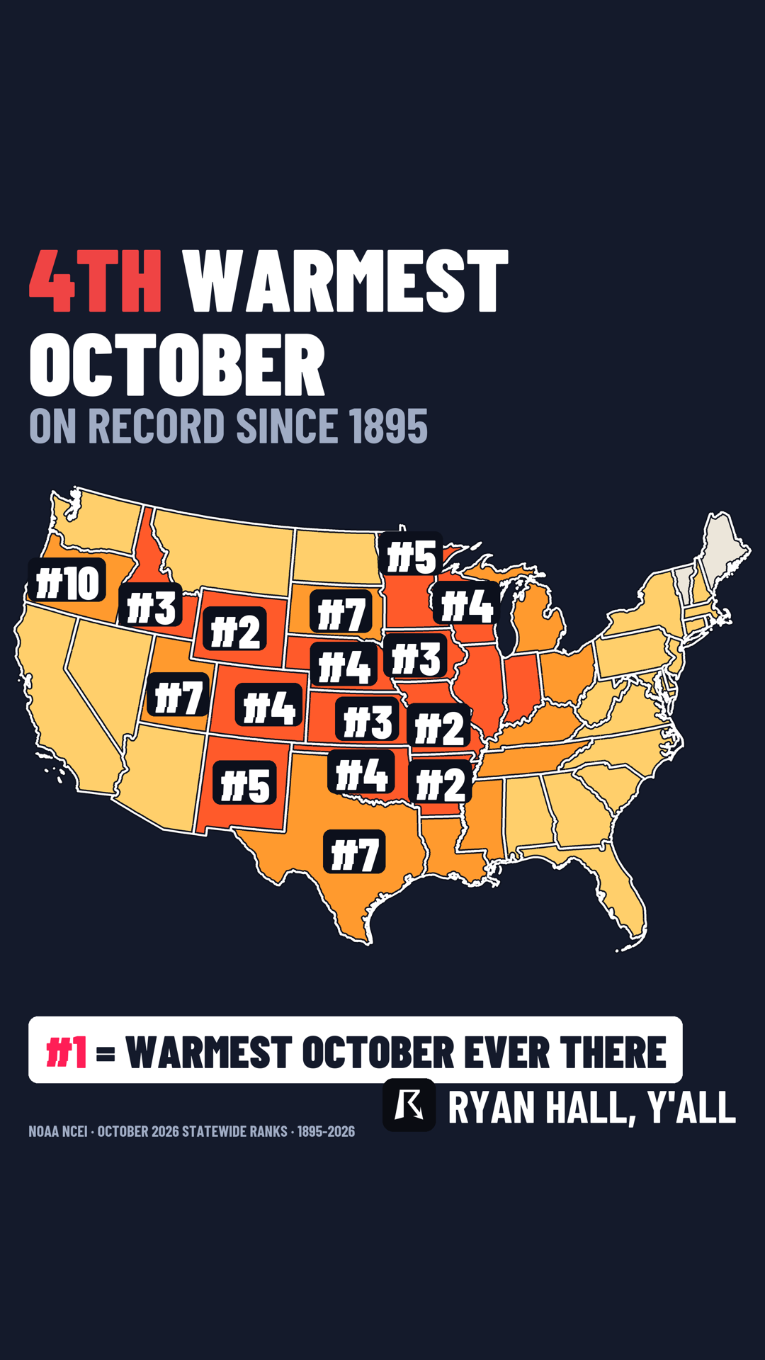
NOAA's new climate report, out Monday morning, ranks October 2026 as the 4th warmest on record for the Lower 48. The month ran more than 4 degrees above normal. Our map shows where each state landed, and the weather this week is already shifting toward something cooler.
October ran more than 4 degrees above normal
A month that far above normal is not a small nudge. Four degrees on a monthly average reflects warmth across the month. Only three Octobers on record were warmer.
States do not all line up the same way, so the national number does not tell you how your own backyard did. Find your state on the map below.
The ranking is a look back at a finished month. It does not say anything about how cold or warm November will be.
Weather this week is already turning the page
The warmth has not vanished everywhere yet. Our winter outlook has a strong ridge of high pressure holding the Plains and Midwest dry and unseasonably mild for now.
Change is coming from both coasts, though. A disturbance and cold front move into the East on Thursday. Thunderstorms are possible along the front and ahead of the trough in the Mid-Atlantic. Isolated strong wind gusts are possible, but the potential for severe gusts is minimal because instability is weak.
Behind that system, cold air wraps in. From Thursday night into Friday, precipitation changes to wet snow on higher ground in West Virginia, western Pennsylvania, Upstate New York and northern New England. The ridges could pick up several inches. Valleys and coastal cities mostly get cold rain. Confidence is moderate. The overall timing looks good, but the exact track of the low off the coast could still shift, and that decides which elevations flip to snow. Lake-effect rain and snow showers follow downwind of Lakes Erie and Ontario into Saturday.
By the weekend, a big area of high pressure settles over the central and eastern US. That brings a cold, dry air mass to much of the country and shuts down thunderstorm chances. Out West, a steady parade of Pacific systems keeps adding mountain snow in the Cascades, the northern Rockies and into northern Idaho and western Montana. Check our winter storm outlook for the latest.
South Texas is dealing with flooding first
Before the cool-down, South Texas has a wet Monday. Our flash flood outlook has Level 2 of 4 (Slight Risk) for portions of far southeastern Texas today. Some areas of South Texas have already had 4 to 9 inches of rain in the past 24 hours, with local totals of 5 to 10 inches near Kingsville. The ground cannot take much more.
Slow-moving storms can still dump heavy rain through the morning and early afternoon, then the threat fades late in the day. A Flood Advisory for Bandera County runs until 4 PM Central for small stream flooding. A Coastal Flood Advisory for coastal Aransas, Kleberg, Nueces, San Patricio, Refugio and Calhoun counties runs until 3 AM Central Tuesday for minor flooding. No flash flood risk is outlined for Tuesday or Wednesday. See the flash flood outlook for updates.
High surf and coastal flooding on the West Coast
Along the Pacific, a Beach Hazards Statement is up through Monday evening for the San Francisco and Monterey Bay areas, with breaking waves of 12 to 16 feet, sneaker waves and strong rip currents. Coastal flood advisories for the San Francisco Bay shoreline run until 4 PM Pacific Friday, with up to 1.6 feet of water over low-lying ground. In Southern California, advisories for Orange County, Los Angeles County beaches and San Diego run until noon Pacific Tuesday. San Diego's west-facing beaches could see surf of 3 to 7 feet. Every active alert is on our warnings page.
What to do
- South Texas: Do not drive through water over the road, especially around Corpus Christi and Kingsville, where the ground is already soaked. Give yourself extra time for the evening commute.
- West Coast beaches: Stay off jetties and rocks, and keep kids and pets back from the water. Waves can run well past the normal wave line.
- Appalachians and Northeast: If you are driving through the high country Thursday night or Friday, check conditions first and watch for slick roads on the ridges.
- Everyone: Sign up for free Y'all Alerts so changes in your area reach you.
Bottom line
October 2026 finished 4th warmest on record for the Lower 48, more than 4 degrees above normal, and that is now in the books. This week the weather turns toward cooler, drier air, after some flooding rain in South Texas wraps up today.
Explained: Flood Advisory, Watch, Warning and Flash Flood Warning explained
More on Weather records, October 2026
Sources
- NOAA NCEI climate records, NOAA National Centers for Environmental Information