Forecasts
Southeast coastal storm odds rise to 60%; Florida flood risk stays Level 3
By Ryan Hall, Y'all Weather Desk · Published
Written by our automated news desk from National Weather Service data.
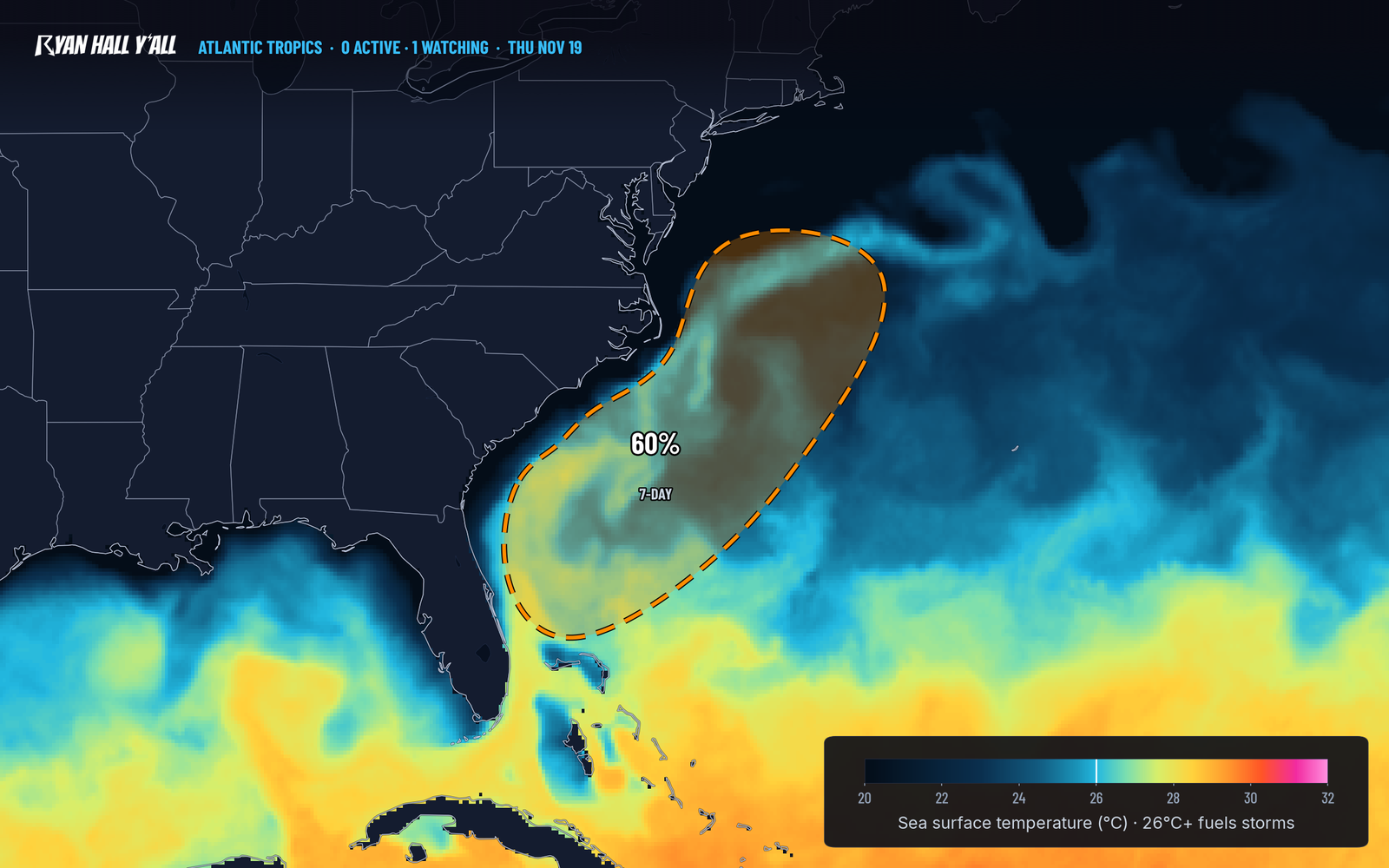
What's new: Hurricane Center odds for the Southeast coastal low rose to 60% from 50%, and Saturday's Level 2 of 4 flood risk now covers coastal Florida, Georgia and South Carolina.
Key points
- Florida's east coast, today and Friday: Level 3 of 4 flash flood risk. Heavy rain keeps falling on saturated ground, so city streets can flood fast.
- Southeast and Mid-Atlantic coasts, Saturday, Nov. 21, into early next week: Gusty winds, dangerous surf and coastal flooding are likely. Heavy rain is possible Saturday along the coast of Florida, Georgia and South Carolina (Level 2 of 4).
- Sierra Nevada, today into early Friday: 2 to 4 feet of snow, locally 5 to 6 feet, with ridge gusts near 100 mph. Travel on I-80 and US-50 over the Sierra can be dangerous to impossible.
- Los Angeles area, today: Level 2 of 4 flash flood risk, with burn scars a particular concern.
- Central California, today: Level 1 of 5 (Marginal) chance of a few severe storms from the San Joaquin Valley to near San Francisco.
A low pressure system is expected to form near the northern Bahamas by late Friday, Nov. 20, and it now has a 60% chance of becoming a subtropical or tropical storm within 7 days, up from 50% on Wednesday evening. Florida's east coast stays under a Level 3 of 4 (Moderate) flash flood risk today and Friday, on ground that is already soaked. Strong winds, rough surf and coastal flooding are likely along the Southeast and Mid-Atlantic coasts this weekend into early next week, named storm or not.
A weekend coastal storm now has 60% odds off the Southeast
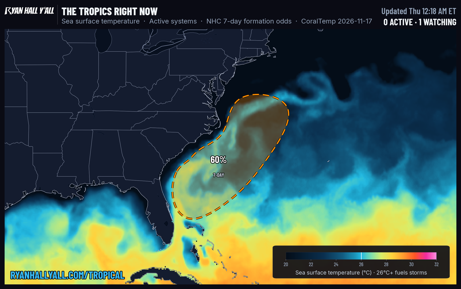
Nothing is named yet. The low is expected to start as a non-tropical system near the northern Bahamas late Friday, then move north or northeast near or just off the Southeast coast through the weekend. The chance it gets a name is 60% over the next 7 days, and it is 0% over the next two. The Hurricane Center is clear that the impacts do not depend on the label. Wind, surf and coastal flooding are likely either way.
What we don't know yet is the track. If the low hugs the coast, the rain and wind come ashore. If it drifts farther offshore, the heaviest rain stays out over the water and the coast gets mostly surf and wind. That part is still up in the air.
If you have beach, boating or coastal plans from Florida up through the Carolinas and Virginia this weekend, check the forecast again Friday. Stay out of rough surf, since rip currents build well before the rain arrives. We will keep the tropics page current if the low gets organized.
Florida's flood risk stays Level 3 today and Friday
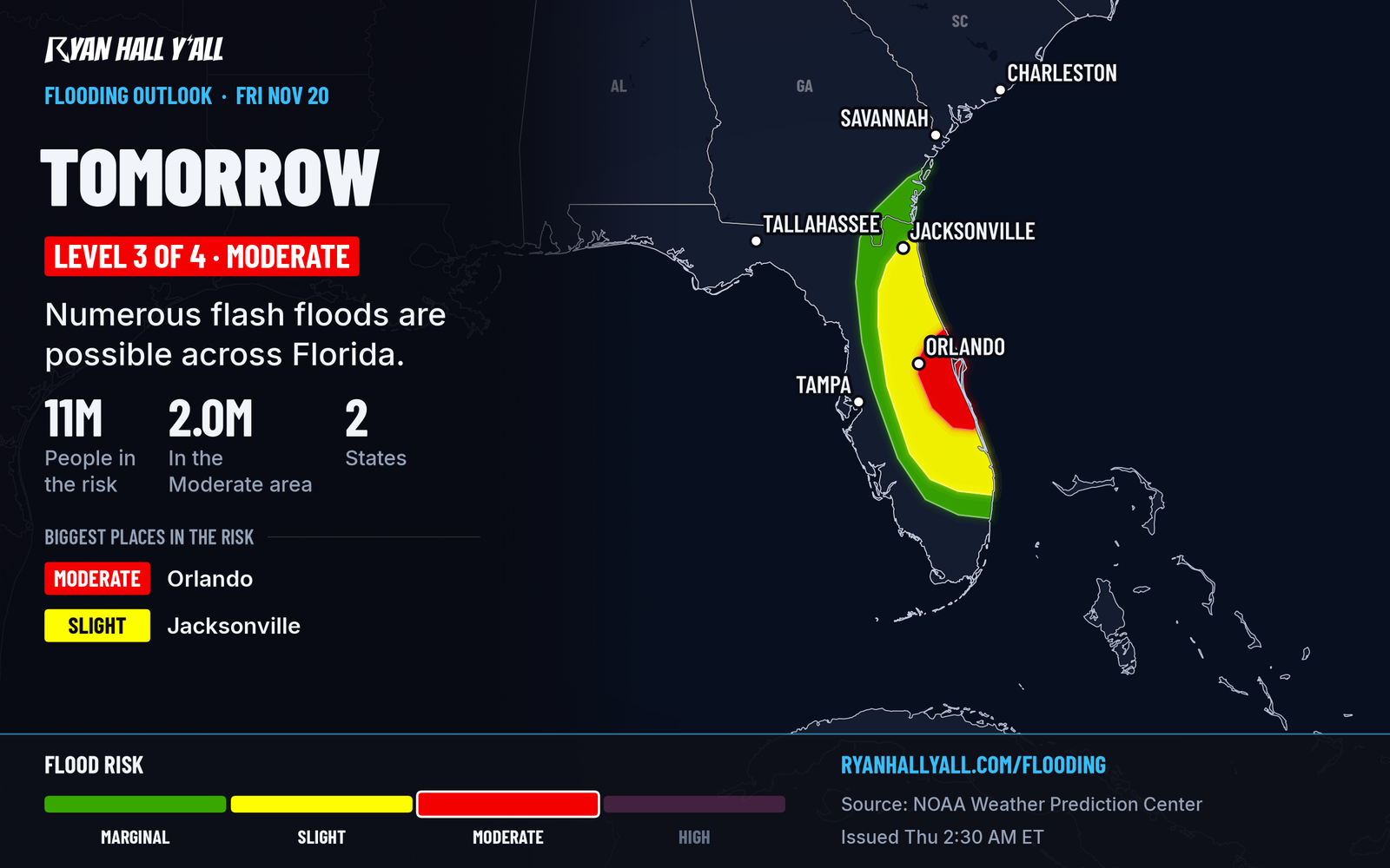
The wettest part of the multi-day rain event is on Florida's east coast. Today's Level 3 of 4 covers portions of eastern and central Florida. Daytona Beach has picked up about 8 inches since Tuesday. Friday's Level 3 runs from the Space Coast up to the Jacksonville area and inland toward Orlando. The St. Johns River near Sanford was already above flood stage Wednesday, so there is little room left for more water.
Heavy bands can drop 2 to 3 inches an hour in spots. Don't drive into water over the road, especially at night, and avoid underpasses and low spots on I-4 and I-95, which our interstate outlook flags for rain. Flooding here has already closed roads and stranded drivers this week, as we covered in our Daytona Beach rain story and our Friday flood risk story. Saturday's risk drops to Level 2 of 4, and it spreads north along the coast. Our flash flood outlook has the latest outlines.
California: deep Sierra snow, burn-scar flooding and a few storms
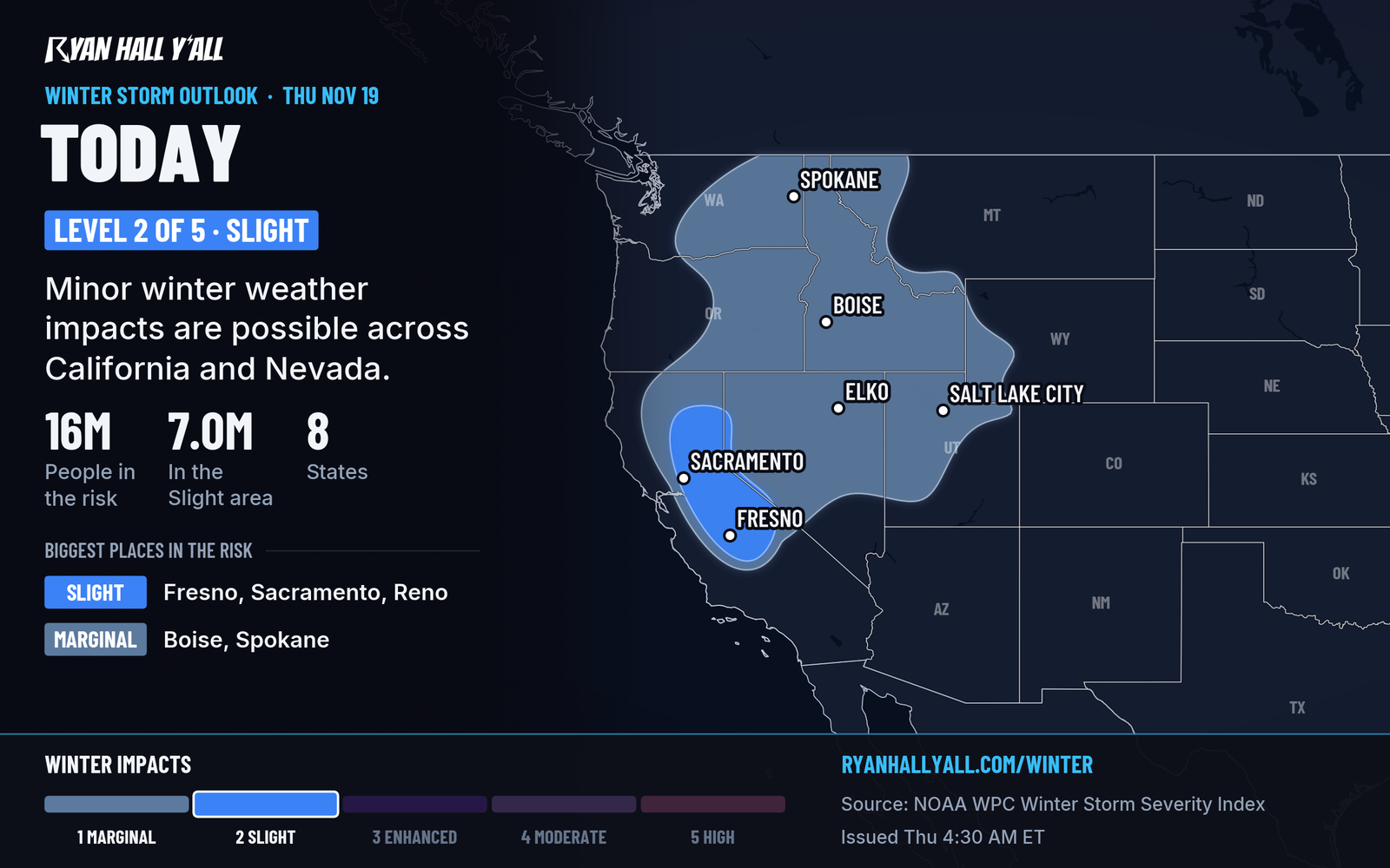
The Pacific storm that has soaked California this week is still at work today. In the Sierra Nevada, 2 to 4 feet of snow is expected, locally 5 to 6 feet, with ridge gusts approaching 100 mph. Travel over Donner Pass, I-80 and US-50 can be dangerous to impossible. Snow levels are falling fast into western Nevada, so Reno, Carson City and Lake Tahoe go from rain to snow.
Near Los Angeles, a Level 2 of 4 (Slight) flash flood risk covers the basin. The Transverse Ranges north of the city could see 1 to 2 inches of rain, much of it in a 3 to 6 hour burst, and runoff off the mountains can flood below burn scars. If you live under a burn scar, be ready to leave if told to. Our earlier story has the details on the LA burn scar evacuation warning.
There is also a Level 1 of 5 (Marginal) severe storm risk for about 13 million people in central California, including San Jose, San Francisco, Fresno and Sacramento. A few storms could produce isolated damaging gusts and perhaps a brief tornado. That's a "keep an eye on the sky" level. Wind has already knocked trees onto Highway 17, I-880 and Highway 35.
Snow shifts into Utah and the Intermountain West Friday
The storm moves inland Friday. Favored ranges, including the Wasatch, Uinta, Tetons and Idaho mountains, can see 6 to 12 inches or more, with snow levels falling to roughly 3,500 to 5,000 feet. That brings snow to foothills and some valleys around Salt Lake City, and our Wasatch story has the timing. Our interstate outlook shows I-80 and I-15 as the rough roads Friday. Check road conditions before heading out.
Looking ahead
A Level 1 of 5 risk covers parts of Kansas, Oklahoma and north Texas on Saturday, Nov. 21. Isolated strong to severe storms are possible. Friday also brings gusty, dry winds and elevated fire weather across central Colorado, southeastern Wyoming and extreme western Nebraska. Today's best weather is across the southern High Plains and Desert Southwest, where skies are sunny and winds are light, and Saturday looks good from Ohio and Kentucky into Pennsylvania and New York. Our Nice Weather outlook has the city-by-city picture. More Pacific storms follow early next week, with another round of heavier rain possible in California Tuesday into Wednesday.
Bottom line
Don't drive into flooded roads on Florida's east coast today or Friday. If you have plans on the Southeast or Mid-Atlantic coast this weekend, plan for wind, surf and coastal flooding, and check back Friday for the track. You can sign up for Y'all Alerts to get warnings for your location.
More on Florida flooding, November 2026
Places in this story: Los Angeles, CA; San Francisco, CA
Sources
- WPC Day 2 Excessive Rainfall Outlook, NOAA Weather Prediction Center, issued
- Ryan Hall, Y'all winter storm outlook, day 1 (our own outlook), Ryan Hall, Y'all, issued
- WPC Winter Storm Severity Index (WSSI), NOAA Weather Prediction Center